Caspar Coastal Trails

map of Caspar area trails
Ocean Drive South Headlands trail Ocean Drive South Headlands trail -- .52 miles one way from parking area through Shore Pine forest to headlands and pocket beach. Mushy after rains.
 
Ocean Drive South Headlands trail North Loop fisherman's trail veers north from trail A near the headlands. Access to tidal shelf - Careful during high surf!
 
Ocean Drive South Headlands trail Return Loop along the creek -- seasonally overgrown, through riparian and back to main trail makes a great loop walk
 
Jefferson Headlands trail Jefferson Headlands trail from parking area opposite Gibney Lane, .67 miles connects to Ocean Drive South Headlands trail. Along the trail, access to another small pocket beach. Access also from parking area at end of Jefferson
 
Jughandle North Headlands trail Jughandle North Headlands trail: Park north of Jughandle bridge, west side (opposite access to Staircase trail (D)), .61 miles on fisherman's trails to headlands. Access to tidal shelf - Careful during high surf!
 
Jughandle Staircase trail Jughandle Staircase Trail: Park at Jughandle State Reserve or north of Jughandle bridge, east side. From the Reserve parking area, 2.28 miles one way of well-maintained trail (sloppy after rains) up several upthrust planes -- beaches -- each 100,000 years older than the last.
 
Jughandle Pygmy Boardwalk Pygmy Boardwalk: The reward at the end of the Staircase: the Pygmy Boardwalk. This short trail loops through pristine Pygmy forest, a unique ecosystem.
 
Jughandle Trails 
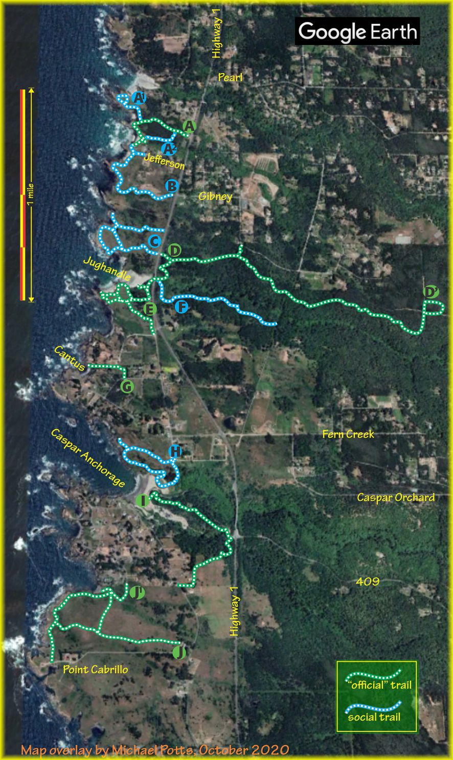
Jughandle Reserve: a network of trails cover the headlands south of Jughandle beach, and to the beach. Mind the edges.
 
Trestle trail Trestle Trail: a rough new trail. Follow the Staircase trail from the Jughandle parking lot under the bridge, thence south (before the stairs) and gently contour up along the brink of Jughandle Creek canyon .97 miles one way to the railroad cut where the Jughandle Trestle stood until April 1906.
 
Cantus Cove access Cantus Cove access is a short trail from Pacifica Drive to the headland above Cantus Cove
 
Caspar Headlands trails 
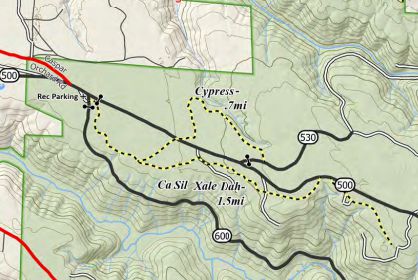
Caspar Headlands: a network of social trails that generally follow the roads of the Caspar Lumber Company on Caspar Headlands State Reserve
 
Graveyard trail Graveyard Trail (aka Caspar Uplands Trail) follows the original Graveyard Road (409) up the ridge from Caspar Beach past the Caspar Cemetery, across the top of Doyle Creek beside Highway One, thence southwest past Sitka Spruce and out to Point Cabrillo Drive .91 miles one way. Easiest parking at Caspar Beach. Trail built by Mendocino Land Trust.
 
Frolic Cove trail Frolic Cove trail starts at the end of Vega Drive in the Caspar South subdivision and leads along the bluff nose to Point Cabrillo Loighthouse and its trail network. Access to tidal shelf - Careful during high surf!
 
Point Cabrillo trails Point Cabrillo trails lead from the State Park visitor center off Point Cabrillo Drive to the Lighthouse, gift shop, and seasonal aquarium.
site copyright © 1999-2023 Caspar Community

CasparCommons.org website is a collaboration between Sienna M. Potts (Siennese.com) & Michael Potts (CasparInstitute.org)
Community web hosting donated by Mendocino Community Network
Thank you, MCN!
for more information, email the Caspar Community Coordinator, caspar@mcn.org
permission to reprint is hereby granted and EARNESTLY desired

printed with 100% recycled electrons!
for website feedback, email the Caspar Village webster