Home   Calendar   Rental   Board   FAQs   Library   Plans

Caspar inside page masthead

Walkable Caspar

opinion (Michael Potts)
 

After living with this land for 55 years, I see a number of apparent discontinuities and inconsistencies in the planning and zoning process worth working on to 'improve the quality of life . . . in Caspar.'

For example, the trail to the fallen trestle from the end of Morand Drive: why was that heroic railroad cut not preserved as a trail, and appended to the State Park (Jughandle State Reserve) property . . . making it possible for East Caspar residents to walk to the beach without crossing Highway One?

How about that famous Coastal Trail: interrupted at least twice between Jughandle and Caspar creeks. To walk that section, one must cross the Caspar Creek Highway bridge, far out of the way and dangerous. A simple easement, like the Land Trust's trail to Cantus Cove, could stitch that back together (although then one must get across Caspar Creek . . .)

Possible now:
  1. The landowner is apparently amenable to preserving a loop around the pond northeast of the intersection of Fern Creek Drive and Highway One. 
  2. Could a larger culvert be set under Highway One so walkers from East Caspar could get to the west side without risking life and limb crossing Highway One?
  3. And how about a trail under Caspar Creek bridge (like the one under Jughandle Creek's bridge) to improve walking access between east and west Caspar?
  4. Before Caspar Creek bridge and 'the freeway' Highway One ran through downtown Caspar and down the bluff into Caspar Creek and across a trestle over the millpond (where cars were sometimes splashed by logs shooting in the pond) -- instead of bicyclists braving the new bridge, why isn't there a bike path and bridge to Point Cabrillo Drive from the south end of Caspar Road?
Ready to walk!
 

Caspar is already a walker's delight. For maps of what's available in walking distance, check the interactive Caspar Headlands map and the Greater Caspar trails maps here.

Inflexibilities in Ukiah-imposed Zoning
 

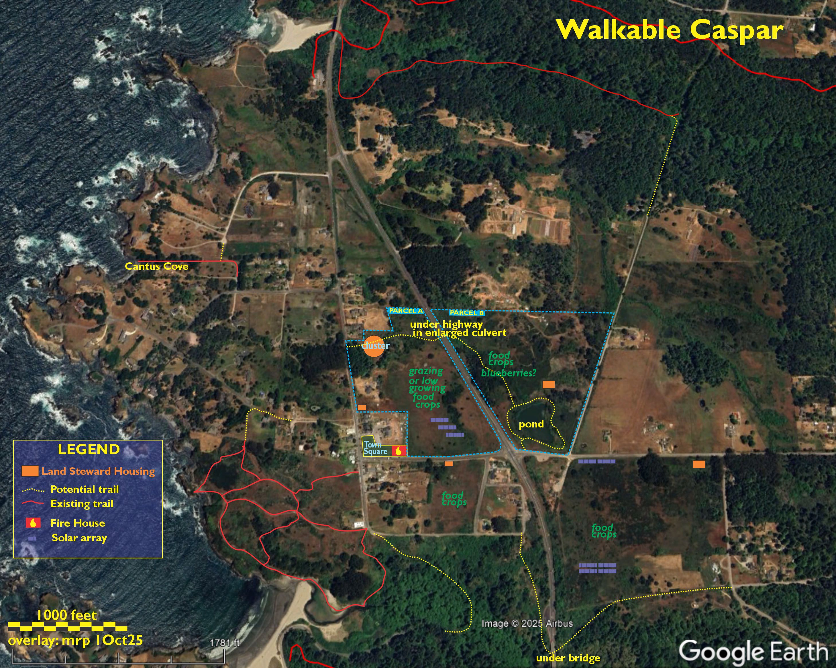
The wallahs who declare what we can and cannot do with our beloved Caspar insist that nothing can be built on the two big parcels that straddle Highway One north of Caspar Street / Fern Creek Drive. (Their reasoning is unsound but it is said it's also unassailable.)

On each of the large open parcels (marked on the map above 'food crops' -- see opposite) a reasonably sized land steward's house, possibly with a barn below for equipment and animals in winter would make the land safer – an unattended pond being an attractive nuisance, for example – while making it possible to restore agriculture to Caspar. Land Trusts, and the Coastal Conservancy, are open to such arrangements, so why is the County standing in the way?

Restoring Caspar's thriving agriculture
 

Records retrieved when the Caspar Lumber Company's Scale House was being renovate showed that In 1904, Caspar shipped more pounds of potatoes than sawn redwood lumber. As recently as 1999, cattle roamed these parcels and controlled the spread of Gorse. We sometimes see goats and sheep on selected areas of these parcels, but too little, too late. 

With the exception of three small private fields adjacent to Jug Handle Nature Center, Caspar's production of edibles is small. (Noted: the Farmstand at Caspar Inn makes their delicious produce available once again.) Gorse, a plague on the planet everywhere but Scotland, is Caspar's most abundant agricultural product. Kudos to those who are working to correct this, and let's try to add some of our abundant open space back into the mix!

comments?

Always welcome; we are a consensus based community.

Send them along to caspar@mcn.org . . . and THANK YOU


CasparCommons.org website is a collaboration between
Sienna M. Potts (Siennese.com) & Michael Potts (CasparInstitute.org)
Website Hosting graciously provided by Mendocino Coast Network

page updated 2025-10-03 (m) – copyright © 1999-2026 Caspar Community, Inc.

../Maps/Walkable ran in 0.031 seconds ( 188 )