|
Please note that the above map and following commentary were placed here for discussion and for information. They are only one person's vision -- mine, Michael Potts's -- of the possibilities and considerations. You may disagree, but please don't attack me for sharing my thoughts. If you have better ideas, or even different ones, please prepare them so they can be displayed here for anyone to see.
17 November 1998
After more than a year of meetings, conversations, and consensus gathering, it appears to me that we are VERY close to a shared vision of what to do with the Caspar Cattle Company lands. My vision has certainly changed since June, 1998.
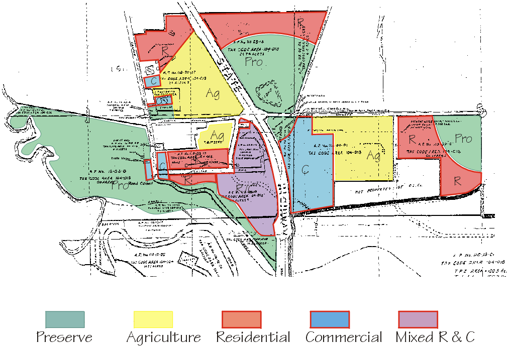
There are undoubtedly small differences between my land use allocations and those held by others, but the point is that these appears to be consensus on much of the use, especially on the land to be protected (Pro) ...which turns out, of course, to be precisely the land a developer would want to subdivide and build on first. One minor difference could be on the parcel including the duck pond; few have walked it -- I have -- and so the amount of land along the northern border which I have marked for residential use (R) might not suit others. This is a good illustration of a fact: if someone can find a way to protect the WHOLE parcel, so much the better! This same strategy could be applied to the section shown as residential just south of the Superintendent's house, and other small areas as well.
Agricultural uses (Ag) -- probably NOT grazing -- would preserve important viewsheds while putting this fertile land to productive use. The commercial section (C) at the foot of the southeastern parcel lies below the viewshed, and minimizes traffic impact on residents of east Caspar. The mixed-use (R/C) section just west of the bridge might be held for a number of years, until just the right development plan is agreed upon. The three large areas mapped for residential use would be best developed as clusters, zero-setback, or some other innovative means of siting homes; it should not need saying that each residence should be developed as sustainably as possible.
|